You will need
- - statement by the Federal Office of unified accounting of land, cadastre and cartography;
- - an application to the Federal office of the state registration of the centre;
- - passport;
- - application to the land Committee of the local administration;
- receipt about payment of state duty for the information provided.
Instruction
1
All information about the land plot located at the Federal Office for the unified accounting of land, cadastre and cartography. To obtain it, contact the service center, complete the application, pay the state fee, submit the passport. You will be given a statement, which will be specified cadastral number of the land plot.
2
The registration of rights of ownership to land plot at the Federal office of the state registration of the center represent the documents. On the basis of Federal law No. 122-F3 in the number of documents are cadastral extract on the land plot, copy of the cadastral plan. The originals of the submitted documents returned to the owner. All copies stored in the archives of the Federal office of public registration center.
3
Extract from the unified state register is not classified as restricted information. To obtain it, contact the registration centre, a statement, a passport and a receipt of payment for the provision of services.
4
Within 10 calendar days will give you the information you need, and you will know the cadastral number of the land plot, as well as all information about its owner.
5
Absolutely free information about the cadastral numbere of the land you can be obtained by contacting the district administration at the location you are interested in real estate. After the survey of any land, all the information is transferred to the district municipality. Contact the land office a statement, please show your passport.
6
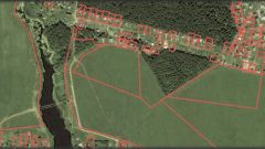
If the land is not delimited and not put on a single cadastral registration in the Federal Office for the unified accounting of land, cadastre and cartography, it has no roomand so it is impossible to know until the procedure of land surveying, which is at the request of the owner of the land.