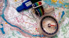
Instruction
1
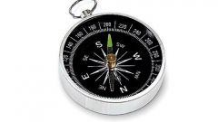
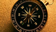
If you imagine a compass, the acute angle between the North (3600) or South (1800), located in one of the quarters of the compass, and this line will be sought by rombom. The index will indicate the direction of light, i.e., for example, GOV will be in the second quarter.
2
The compass points marked with broad and narrow triangles. 32. The angle between adjacent equal to 11°15`. The value is called this angle. One direction - 11°15`, two points 2х11°15`= 22°30`, etc.
3
Calculus in the common kitchen is used in marine navigation. North, South, West and East are referred to as principal. The rest are combined from the names of the home, such as Sz. Also Rumba and are denoted by Latin letters, N – North, S –South, E – East, W – West.
4
To navigate using 32 Rumba. In meteorology the direction is defined from the center of the visible horizon to the points of its circumference. Here is important only the visible horizon, which is divided at 16. In surveying bearing - the angle, compiled by the geographic Meridian with the line, it does not exceed 900.
The calculation of the Rumba starts with the definition of the cardinal directions on the compass, and deposition from the line of the Meridian desired value. For example, 3 Rumba in the North-East means 3х11015`=33045` on East from the North Meridian.
The calculation of the Rumba starts with the definition of the cardinal directions on the compass, and deposition from the line of the Meridian desired value. For example, 3 Rumba in the North-East means 3х11015`=33045` on East from the North Meridian.
5
In surveying points are used to determine the direction and orientation of lines. The value is also designated by the letter r and accompanied by a letter of direction and digital angle symbols, for example: SE: r15015`. This means that the designated line will be in the direction 15015` on East from the South Meridian, i.e. in the second quarter of the circle of the compass.
Recently, however, to determine the direction of the line and orienteering in most cases uses a simple degree system.
Recently, however, to determine the direction of the line and orienteering in most cases uses a simple degree system.