You will need
- - various cards;
- - the range;
- calculator.
Instruction
1
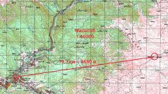
If the plan or map marked the item sheet, a special table to determine the scale of the map. For example, if a map sheet is labeled M-35-A, its scale is 1:500000. This means that 1 cm on the map, the terrain is 500000 cm or 5 km.
2
If mark does not exist, note the kilometer grid, which is applied to any topographic map. Side of the square of this grid corresponds to a fixed number of kilometers. Measure with a ruler the side of the square in inches and find the ratio of the distance on the map to real. This will be the scale. For example, if the stack on the map at 4 km and the distance between the lines is 2 cm, then the scale will be equal to 2:4 km=2:400000 cm=1:200000 see
3
If the map is larger scale with Parallels, then define it by using this grid. To do this, measure the distance between the two caused by a number of Parallels in inches. These adjacent Parallels from the larger numerical values subtract the lesser. Since one degree of parallel corresponds to 111 km, directly on the ground, multiply the difference by that number, and the number 100000 in order to convert this distance to centimeters.
4
Find the ratio of the measured range of distance to the calculation result. Get the scale of the map. For example, if Parallels are 0?, 10?, 20? etc. find the difference of two nearby lines. She will be 10. Then, multiply this number by 111 and 100000. Get 10•111•100000=111000000. If the distance measured by the ruler is equal to 4.5 cm, will receive a scale of 4.5:111000000 cm?1:25000000, see This means that one centimeter in the map fits 250 km area.
5
Measure the scale of real distances. For this known distance mark on the map, and correlate with the real. For example, if the distance between the two cities is 400 km, and on the map it is equal to 8 cm, find the ratio of 8:400 miles=8:40000000=1:5000000. This is the scale of the map.