Instruction
1
Just in case, check, maybe you just did not notice this inscription. In diagrams and drawings it should be listed in the stamp. This may be a sign of a complete format "1:20 Scale" or abbreviated "1:20". On topographic maps and schemes of the indication of scale is also a required element Saramago clearance. It can be specified in the header of the card, which is located at the top or bottom. Sometimes the inscription, showing the scale is in the text of the map legend or directly on it. Carefully review the diagram or map.
2
If you can not find the instructions of the scale in the diagram, the engineering details or construction plan that identifies the size details in inches or measurements in meters, you can determine the scale yourself. Measure the dimensions on paper usual line in millimeters or fractions of an inch. Divide the value specified on the diagram, expressed in millimeters or inches, that you got when measuring. This will be the denominator of the desired scale of the drawing or plan.
3
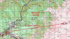
In a similar way you can find the map scale or topographic scheme. You should carefully look at the map and define a couple of characteristic objects located on the terrain. For maps of large scale, this can be buildings, tubes of boiler. For maps and schemes on a small scale you can use the tops of hills and mountains, a fork in the road, other characteristic points of the relief and terrain. Measure with a ruler the distance map between these characteristic objects.
4
If you have a map of the same area with known scale, measure it the distance between the same feature points and make a conversion scale. If no such card, then use the mapping services of Google or Yandex. Find this area on satellite images, which are the basis of these services and define in it the same characteristic points which you found on the map or the diagram. Select the Ruler tool, measure the images distance and calculate from these data and measured on the map the distance scale of your map.