You will need
- - surveyor's compass or roulette
- - topographic map;
- - level;
- - paper and pencil.
Instruction
1
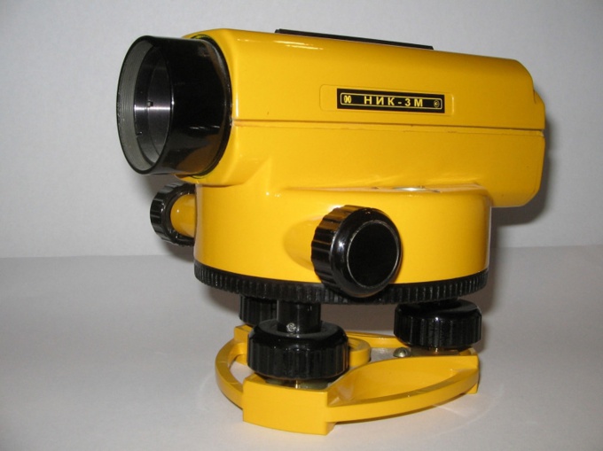
The most convenient way to determine the slope leveling. This tool allows you to determine the distance between the points, and the height of each in relation to the level of the surface of the Earth. Modern digital levels are equipped with storage devices. To determine the bias remains only to find the difference between them.
2
The formula for calculating the slope in percent in this case can be represented as a simple fraction .The numerator of it is of a level difference and the denominator is the distance between them. All this is multiplied by 100%. Thus, the formula is: i= ∆ H/l*100%, where Δh is the difference between the marks, l is the distance, a i – gradient.
3
However, not always it makes sense to buy rather complicated and expensive tool. Significantly more likely to use those funds that are available. Such situations most often faced while gardening. Select two points of markers are known to you. They can for example be indicated on the site plan that is made at the breakdown site. Maybe get a large-scale map, where notation is often. On the site and mark these points with pegs and measure the distance between them using the surveying of a compass. Then use the same formula as in the use of leveling. The distance should be expressed in meters.
4
If you need to determine the slope on a topographic map, look closely at the notation. There definitely is horizontal and level. Horizontal in topography is called the trace of the intersection of the physical surface of the Earth, with its level surface, and all points of a particular horizontal line have the same absolute value of height. Mark expresses the numerical value of the height of a particular point. In the lower right corner of topographical maps there is always a schedule of foreclosures, which can be used to quickly determine the angle of inclination.
5
When working with a topographic map, consider a few things. Mark the points locate the nearest horizontal. If the point is on the line, the numerical value of its level exactly matches the specified value. For points located between contour lines, interpolation method is applied. In the simplest cases, is just average. Distance, calculate scale. Find the ratio of the level difference and the distance between the points and multiply the fraction by 100%.
Note
On topographic maps the height of numeral marks directed upward relief.